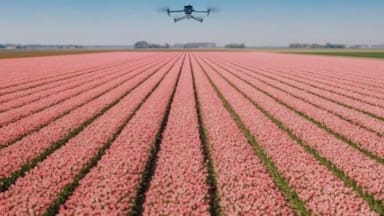
Cunningly, the newly developed model leverages artificial intelligence to analyse vast amounts of drone data, resulting in a detailed map that pinpoints – with millimetre precision, plants that are diseased or at risk. By means of this accurate and early detection of potentially harmful crop conditions, any required crop protection can be applied specifically, significantly reducing usage.
According to the researchers the model is currently only capable of recognizing botrytis in tulips and hyacinths but it is expected that capabilities will be extended to detecting other diseases in different crops.
A truly intriguing development, not just from an environmental perspective but also for growers in terms of potential cost savings through reduced risk of crop failures, reduced requirements of crop protection agents, and eliminating the need for manual field inspections.
The ‘Remote Sensing for Horticulture’ project is working on improving the accuracy of the measurements by combining drone data with satellite imagery and current information on soil and weather conditions. In addition, exploring how the technology can detect other diseases in different crops.
This project was made possible by the municipality of Katwijk, Holland Rijnland, and Drone-Engineering & Operations students from the ROC of Amsterdam.
