Researchers at the UK Centre for Ecology & Hydrology (UKCEH) hope this mapping will guide planting and restoration of these vulnerable habitats to support wildlife and mitigate climate change.
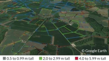
UKCEH’s new map, derived from aerial laser scanning of England’s entire landscape, provides precise information on the quantity and length of hedgerows, and height measurements which is a crucial indicator of hedge quality.
Ever since the since the Bronze Age, hedgerows have been integral to our rural landscape, traditionally marking out boundaries and keeping in livestock. Made up of diverse plant species, hedgerows provide vital habitats for nesting birds, small mammals and insects, and are able to capture and store large amounts of carbon.
Unfortunately, it is estimated that approximately half of Britain’s hedgerows were lost between the 1940s and 1990s, mostly in England, due to housing development and agricultural intensification. While the loss has slowed since the 1990s, neglect, damage, poor management and removal remain threats.
Dr Richard Broughton, who led the UKCEH hedgerow map project, says: “Hedgerows are not only an intrinsic part of England’s rural heritage, they can also be a real asset in helping to tackle the biodiversity and climate crises.”
Key research findings:
- A total of 390,000 km of hedgerows (1-6 metres tall) exist on field boundaries in England – enough to go round the world almost 10 times.
- The South-west boasts the highest hedgerow densities, led by Cornwall with an average of 5.1 km per 1km x 1km square.
- The lowest densities, excluding major urban areas, are found in Surrey (1.2 km), Hampshire (1.5 km), and Berkshire (1.7 km) per 1km x 1km square.
- 67,000 km of lines of vegetation below 1m look to be degraded, cut or newly-planted hedges, and a further 185,000 km above 6m tall, which includes mature hedgerow trees and many overgrown hedges that have become lines of young trees.
As per the Environmental Improvement Plan, the Government has pledged to support farmers to create or restore 30,000 miles of hedgerows a year by 2037 and 45,000 miles a year by 2050. The new UKCEH data will be important to guide future habitat restoration.
